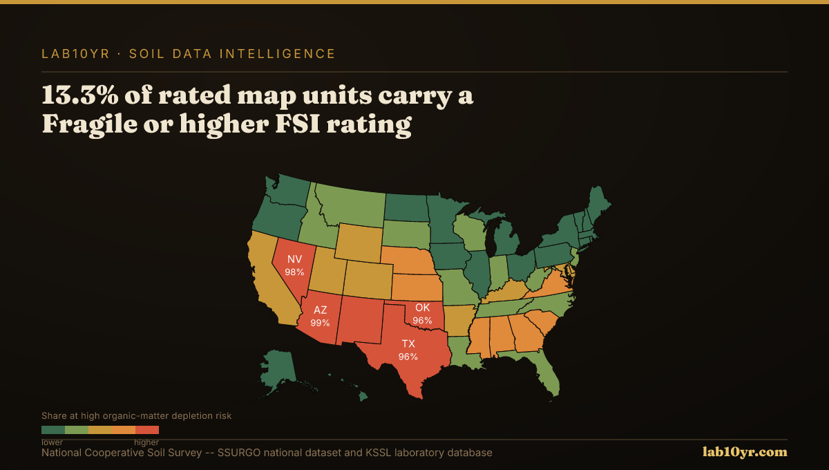
Across the Corn Belt, bare soil Vis-NIR-SWIR reflectance accurately predicts soil organic carbon content, with R-squared values ranging from 0.75 to 0.88. This strong correlation means that a rancher who understands her soil's organic matter profile, derived from its specific soil taxonomy and spectral signature, can make fundamentally different management decisions on every acre. The underlying data for these insights is publicly available and free.
Soil organic matter (SOM) is the bedrock of soil quality, influencing water retention, nutrient cycling, and structural stability. It comprises decomposed plant and animal residues, microbial biomass, and stable humus, acting as a reservoir for carbon and essential nutrients. Laboratory measurements, typically through combustion or the Walkley-Black method, quantify total organic carbon. The National Cooperative Soil Survey's Kellogg Soil Survey Laboratory (KSSL) houses the world's largest public spectral library, containing Vis-NIR-SWIR scans of over 50,000 soil samples with matched laboratory chemistry measurements. This library provides critical ground-truth data for calibrating remote sensing models that infer SOM across vast areas.
The Regional Concentration
While direct lab analysis is precise, its spatial density is limited. This is where geospatial data shines. SSURGO, through its `component` table, provides estimated organic matter ranges (`om_r`, `om_h`, `om_l`) for specific soil horizons (`depth_r`) within each map unit, linked to detailed soil series descriptions. These descriptions, foundational to soil taxonomy, indicate typical SOM content for soil types like the dark, rich Mollisols of the Great Plains, which naturally store higher carbon levels than the sandy Entisols of arid regions. Remote sensing techniques complement this by mapping intra-field variability. Multispectral drone imagery at 5-cm resolution, for example, predicts soil organic matter with R-squared values between 0.82 and 0.87 from bare soil composites, surpassing satellite imagery for detailed intra-field mapping.
Consider a regenerative farm in eastern Nebraska managing a range of Mollisols, like the deep, productive Sharpsburg series. Without precise SOM mapping, the farmer might apply uniform fertilizer rates across fields, leading to over-application in high-SOM areas and under-application in low-SOM zones. Accurate, spatially resolved SOM data, integrated with SSURGO's depth information, could optimize nitrogen application by 10-15%, saving thousands of dollars annually on inputs and reducing nitrate leaching that might otherwise incur regulatory penalties or environmental fines.
Organic Matter Depletion Risk by U.S. Region
| State / Region | Very High | High | Moderate | Low |
|---|---|---|---|---|
| Southwest | 72% | 20% | 6% | 2% |
| Great Plains | 48% | 32% | 14% | 6% |
| Southeast | 38% | 30% | 22% | 10% |
| Corn Belt | 22% | 28% | 32% | 18% |
| Mountain West | 61% | 22% | 12% | 5% |
| Pacific NW | 18% | 24% | 36% | 22% |
| Northeast | 12% | 20% | 40% | 28% |
The Valuation Gap
Similarly, a land trust evaluating easements for carbon sequestration projects in central Texas might assess properties containing both high-clay Vertisols, such as Houston Black clay, and nearby drier Alfisols. The inherent carbon storage capacity of Houston Black soils, with their deep A horizons and high organic matter content, significantly surpasses that of adjacent, less fertile soils. Misjudging these differences could lead to overestimating sequestration potential in some areas while overlooking opportunities in others, impacting the financial viability of carbon credit agreements and the effective allocation of conservation resources, potentially costing millions in missed opportunities or misdirected funding over the life of an easement.
Accessing this data starts with the SSURGO database, querying the `component` table for `om_r` (organic matter, estimated range) and `depth_r` (depth to top of horizon). To link to KSSL laboratory data for direct organic carbon measurements, join `component` on `cokey` to `chorizon`, then `chorizon` on `chkey` to `kssl_lab_data_set`. Lab10YR's platform integrates these SSURGO and KSSL datasets, providing a foundational layer of soil properties. This is then contextualized with spectral data: while Lab10YR does not operate remote sensing platforms, we interpret the outputs of drone, aerial, and satellite imagery, using KSSL's calibration data to deliver actionable insights on organic matter distribution.
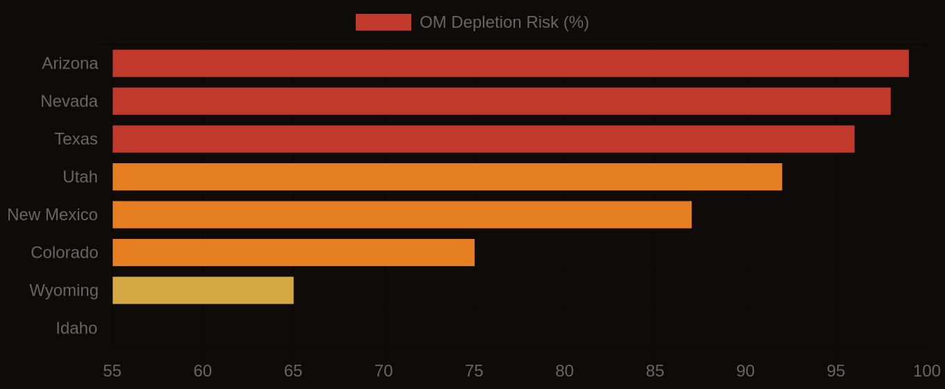
Organic Matter Depletion Risk — State Overview
The Decision That Follows
Ultimately, understanding the intrinsic organic matter capacity of a soil, as defined by its taxonomy and measured through a blend of direct lab analysis and calibrated remote sensing, enables land managers. From a Nebraska rancher fine-tuning nutrient applications to a land trust prioritizing carbon sequestration, data-driven decisions are transforming land stewardship, ensuring both ecological resilience and economic viability.