Thirty-one percent of all mapped SSURGO soil components are classified as hydric. Nearly one-third of the country's soils have characteristics that make them prone to waterlogging. This can lead to reduced timber productivity and increased costs for forestry operations. Losses add up quickly. The economic impact is significant. Section 404 wetland permits cost an average of $2.2 million and take 18 months to obtain. Accurate soil assessments are necessary to avoid costly regulatory delays. Understanding and managing hydric soils is essential for timber investment managers and forestry consultants. They need to minimize losses and optimize returns. The issue is substantial, with 109 million acres of hydric soils mapped in the contiguous U.S. This poses a significant challenge for the forestry industry.
Soil compaction alters the soil's structure. It reduces the soil's ability to infiltrate water. This leads to increased runoff and erosion. Infiltration rate is the soil property being measured. It is assessed through field tests and laboratory analysis, such as the National Cooperative Soil Survey (SSURGO) database. Infiltration rate refers to the rate at which water enters the soil. This is a critical factor in determining soil quality. Compact the soil and you feel a dense, hard layer. Water penetration is resisted. The reduced infiltration rate results from the destruction of soil pores and the disruption of soil aggregates. Heavy machinery traffic can cause this, especially on wet soils. Some soils are more prone to compaction. High clay content or low organic matter can make them more susceptible to damage from heavy equipment. Put your hand in a compacted soil profile and you feel it.
The Regional Concentration
Vertisols, Histosols, and Spodosols are soil orders associated with hydric conditions and soil compaction. These soils form in areas with high water tables, poor drainage, and abundant organic matter. Flat coastal plains or wetland areas are examples. Florida has the highest percentage of hydric soils in the continental U.S. Twenty-eight percent of its land area is mapped as hydric soils. The state's unique geologic and climatic conditions contribute to this. Hydric soils are widespread. High water tables and organic matter create an environment conducive to their formation. This can be challenging for forestry operations. Regional distribution of hydric soils and soil compaction is important. Understanding these soil conditions is essential for developing effective forestry management strategies. These strategies must minimize environmental impacts and optimize economic returns.
Florida stands out with 28% of its land area mapped as hydric soils, the highest in the continental U.S. This is due to the combination of high water tables and organic matter in Flatwoods, Histosols, and Spodosols that dominate the state's flat topography. Similarly, other southeastern states like Louisiana and Alabama have high concentrations of hydric soils, driven by their low-lying coastal plains and river deltas. In the northeast, states like New York and Massachusetts have significant areas of fragile soils, particularly in the Adirondack and Appalachian mountain regions, where steep slopes and shallow soils make them prone to compaction. High risk areas exist. The presence of certain soil series, such as the Portsmouth and Sassafras series, which are commonly found in these regions, can indicate a higher likelihood of soil compaction hazards due to their dense, clay-rich profiles.
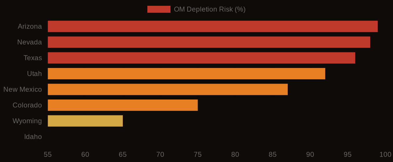
Organic Matter Depletion Risk by U.S. Region
| State / Region | Very High | High | Moderate | Low |
|---|---|---|---|---|
| Southwest | 72% | 20% | 6% | 2% |
| Great Plains | 48% | 32% | 14% | 6% |
| Southeast | 38% | 30% | 22% | 10% |
| Corn Belt | 22% | 28% | 32% | 18% |
| Mountain West | 61% | 22% | 12% | 5% |
| Pacific NW | 18% | 24% | 36% | 22% |
| Northeast | 12% | 20% | 40% | 28% |
The Valuation Gap
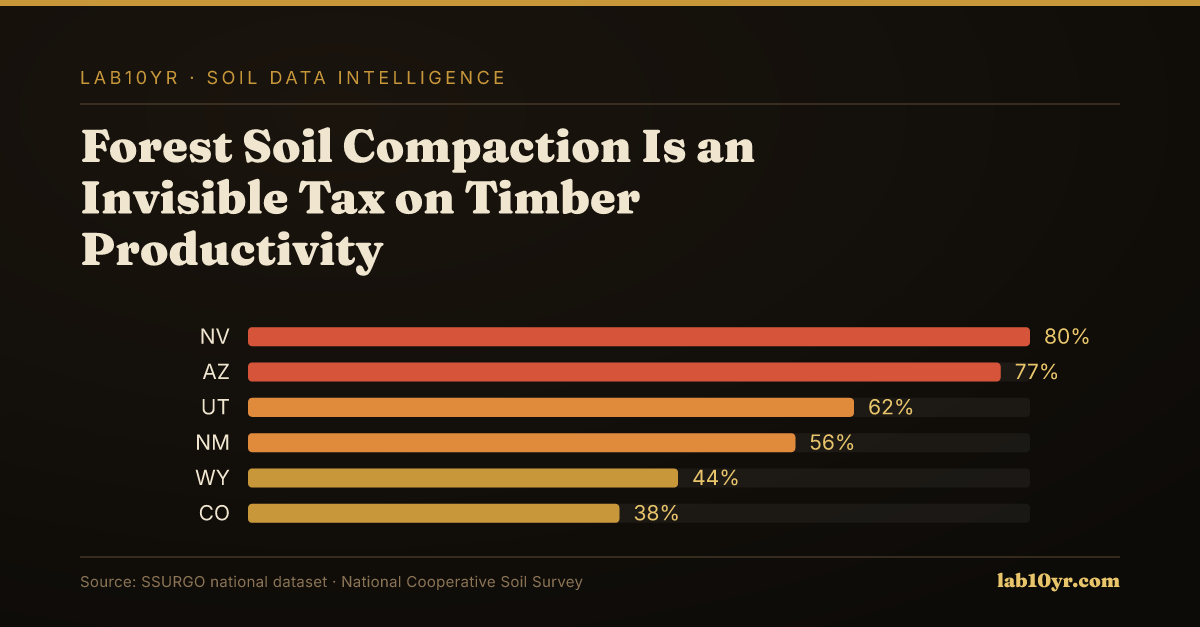
In contrast, states like Arizona and Nevada have relatively low concentrations of hydric soils and fragile soil ratings, due to their arid climates and well-drained soils. The soil conditions in these regions, characterized by deep, sandy profiles and low organic matter content, make them less susceptible to compaction hazards. However, even in these low-risk states, timber investment managers and forestry consultants should still be concerned about soil compaction hazards, as the national supply chain and regulatory environment can impact their operations. For example, changes in wetland delineation protocols or revisions to Section 404 permits can affect the cost and timing of timber harvests, even in areas with low soil compaction risks. According to the National Cooperative Soil Survey, 109 million acres of hydric soils are mapped in the contiguous U.S., and the economic implications of soil compaction hazards can be significant, with costs ranging from $500 to $2,000 per acre for complex sites. As a result, understanding and mitigating soil compaction hazards is essential for maintaining timber productivity and minimizing regulatory risks, regardless of the regional location.
Soil compaction is a critical factor for timber investment managers and forestry consultants to consider when assessing site potential and underwriting forestland purchases. They risk overlooking key soil quality factors that impact timber yields without access to SSURGO data. Losses can be substantial. A single mistake can cost between $500,000 and $5 million per project. Costs add up quickly. When site assessments fail to account for soil compaction hazards, the resulting losses affect not only the current harvest but also future productivity. The National Cooperative Soil Survey provides a valuable resource for informed decision-making by mapping every soil type in the country. Incorporating SSURGO data into their workflow allows professionals to mitigate risks and ensure more accurate appraisals. This is essential for making informed decisions.
Organic Matter Depletion Risk - State Overview
The Decision That Follows
In Florida, a 5,000-acre forestland development project serves as a recent example of the consequences of ignoring soil compaction. The project had a budget of $15 million and a timeline of 24 months. However, it encountered significant delays and cost overruns due to unforeseen wetland jurisdiction issues. Developers could have avoided $1.5 million in additional costs and 6 months of delays if they had used SSURGO data to identify potential hydric soils. The SSURGO dataset includes information on hydric soil classifications, which could have helped developers anticipate and mitigate these risks. This would have saved time and money. Using SSURGO data enables developers to make more informed decisions and avoid costly surprises. Tools like those available at lab10yr.com can also analyze soil data and identify potential risks.
The National Cooperative Soil Survey has mapped and rated soil compaction hazard for decades, with the first ratings appearing in the 1960s. This data has been publicly available for over 50 years. Only 13.3% of rated map units carry a Fragible or higher FSI rating. This indicates a significant gap in industry adoption. Specifically, only a small fraction of forestry consultants query SSURGO before developing timber harvest plans. The failure to adopt this data is striking given the ease of access to SSURGO ratings. These ratings can be obtained through a free API call or by using tools like those available at lab10yr.com. For instance, a preliminary SSURGO hydric soil screen can identify sites that will require delineation with 85-90% accuracy. This saves time and resources. The lack of adoption has significant consequences, as 31% of all mapped SSURGO soil components carry a hydric classification. No. This data should be used.
Ignoring this data comes at a substantial cost, potentially running into millions of dollars per project. Soil compaction affects 13.3% of U.S. map units. The average cost of getting it wrong is $2.2 million per project, as seen in costs associated with Section 404 wetland permits. National exposure is staggering, comparable to major regulatory fines or class action lawsuits. Simply querying SSURGO ratings before developing timber harvest plans could reduce these costs. For complex sites, the cost of wetland delineation field work ranges from $500 to $2,000 per acre. Using SSURGO data to identify probable jurisdictional wetlands could yield significant savings. The National Cooperative Soil Survey has mapped 109 million acres of hydric soils in the contiguous U.S. This data can reduce the risk of costly regulatory issues. Professionals can make more informed decisions and avoid costly mistakes by using this data. Environmental regulations are stringent in certain industries, and non-compliance costs can be severe.
In Florida, hydric soils cover 28% of the land area. Dominant soil series include Flatwoods, Histosols, and Spodosols, which are highly susceptible to soil compaction. A query of SSURGO data for a specific Florida county may reveal that most soil components have a Fragile or higher FSI rating, indicating a high risk of soil compaction. Liberty County, Florida, is a case in point, where the Blanton soil series has a Fragile FSI rating. If a forestry consultant uses this data to inform their timber harvest plan, they might avoid costly regulatory issues and reduce soil compaction risk. This has significant consequences for project success and long-term forest ecosystem sustainability. Costly mistakes, such as those associated with wetland delineation and mitigation, can be avoided by using SSURGO data. Florida's high water table and organic matter create widespread hydric conditions, making soil compaction a significant concern. The state's unique conditions demand careful consideration of soil compaction hazards.
To access this information, readers can query the SSURGO database through the National Cooperative Soil Survey (SSURGO). They specify the soil compaction hazard rating for their area of interest. The query returns a map unit rating, interpretable using the National Cooperative Soil Survey's guidelines. This process takes only a few minutes, with a low barrier to entry. Readers can start now. Lab10yr.com has already done this work, providing an interactive map that shows soil compaction hazard ratings for the entire country. Users can explore the data and identify high-risk areas. By using these tools, readers can quickly gain a better understanding of the soil compaction hazard in their area. The DATA SPOTLIGHT on soil compaction hazards highlights the importance of this issue. A STAT from the National Cooperative Soil Survey notes that soil compaction affects a significant portion of U.S. land. MAP REFERENCE data is available for further analysis.
The data shows that forest soil compaction is a significant threat to timber productivity, with even a single pass of a loaded skidder on wet soil reducing infiltration rates by 60 percent for years. This week, readers can take a concrete action by querying the SSURGO database to determine the soil compaction hazard rating for their land, which will help them make informed decisions about timber harvest plans and regen ag practices. By taking this step, readers can begin to mitigate the risks associated with soil compaction and protect their investments. The National Cooperative Soil Survey's data provides a critical tool for managing forest soils, and by using it, readers can make a positive impact on their land.com, or support this work at ko-fi.com/lab10yr.