You do not need InSAR to know a site is going to move. The soil tells you. Areas prone to subsidence are often flagged by specific soil characteristics, detectable through advanced terrain analysis before any satellite flies over. Consider the highly organic soils of coastal plains or historic floodplains, where the decomposition or dewatering of peat leads to measurable ground lowering, impacting any infrastructure built upon it.
This phenomenon, known as subsidence or soil settlement, arises from changes in the bulk density of the soil profile. Highly organic soils, characterized by significant amounts of decomposed plant and animal material, possess inherently low bulk density and high water content. When these soils are drained, dewatered, or subjected to load, the organic matter oxidizes or compacts, leading to a permanent, irreversible reduction in soil volume. The National Cooperative Soil Survey quantifies this with properties like `om_r` (organic matter content) in the `chorizon` table and `drclassdcd` (drainage class) in the `comp` table, indicating conditions prone to such settlement.
State by State
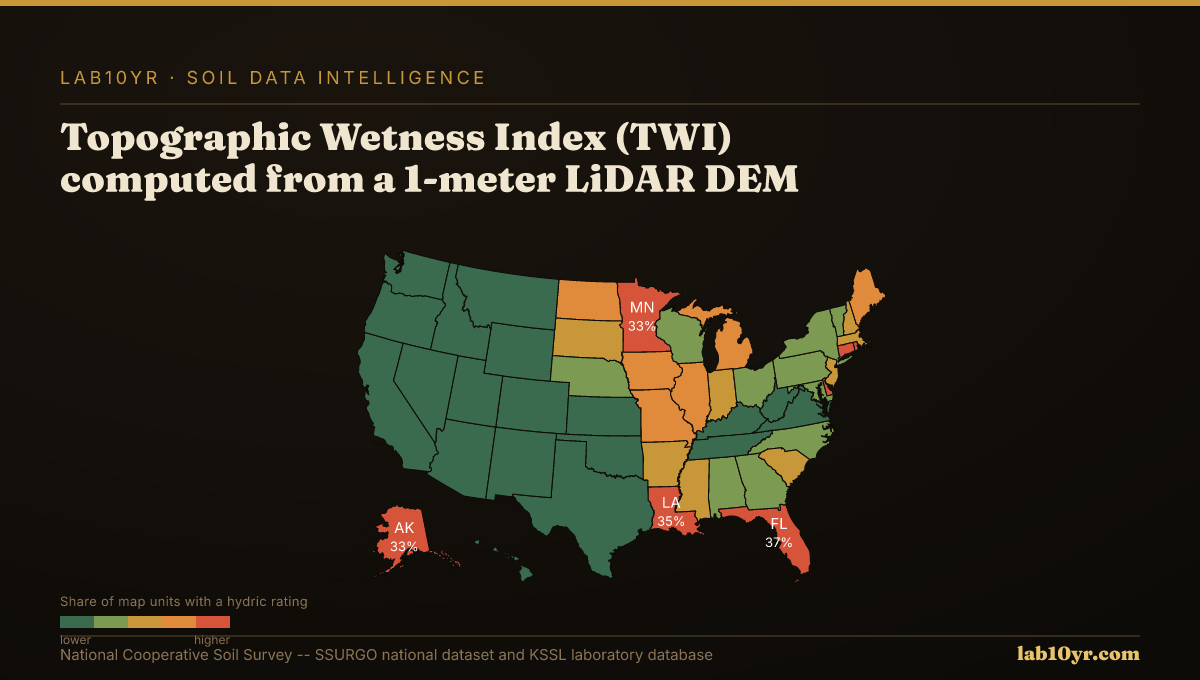
While direct measurement of these properties requires site-specific soil sampling, high-resolution LiDAR terrain models offer powerful predictive proxies. For instance, the Topographic Wetness Index (TWI), a derived product from 1-meter LiDAR, predicts SSURGO drainage class with 78-84% accuracy. Poorly drained, depressional areas, often identified by high TWI values, are prime candidates for organic soil accumulation and subsequent subsidence risk. Geomorphon landform classification, also from LiDAR, identifies 10 terrain element types that consistently correspond to distinct soil drainage and organic matter conditions, further flagging potential settlement zones.
For civil engineers designing pipelines or municipal utilities planning wastewater infrastructure, knowing where settlement is likely can prevent costly repairs and service disruptions. LiDAR terrain derivatives predict soil series with 70-85% accuracy in cross-validation studies, allowing for early-stage identification of specific soil series known for high compressibility, such as Histosols or Mollisols in poorly drained settings. Without ever deploying ground sensors or satellite missions, engineers can anticipate problematic areas and adjust foundation designs or right-of-way planning.
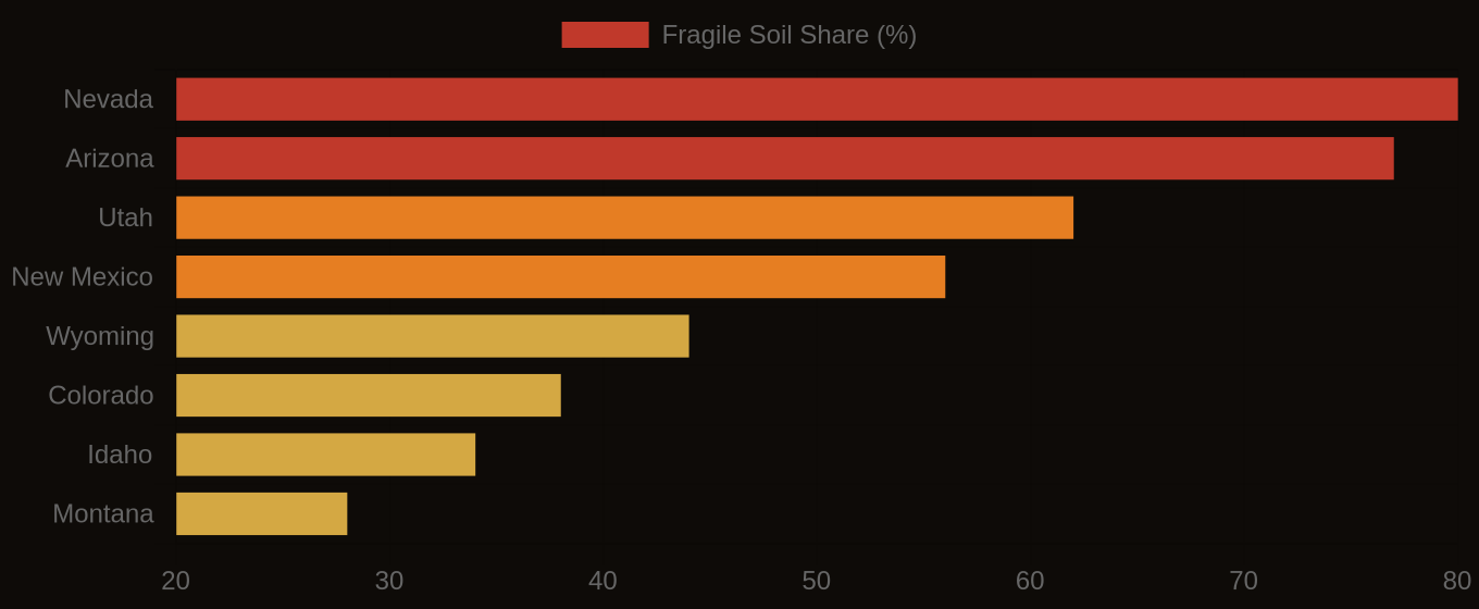
Multi-Hazard Soil Risk — Five Western States Compared
The Data Behind the Map
Consider a municipal water line project in coastal Louisiana, where highly organic Lafitte soils are prevalent. If not accounted for, differential settlement can lead to pipe rupture, requiring emergency repairs that can cost hundreds of thousands of dollars per incident, not including service interruptions. Pre-construction analysis using LiDAR-derived TWI and SSURGO data could identify precise segments of the right-of-way susceptible to extreme settlement, prompting engineers to specify flexible pipe joints or deeper pilings in those areas, avoiding catastrophic failure.
Similarly, a new warehouse development in a historic floodplain along the Willamette River in Oregon, built on poorly drained Dayton soils, faces significant long-term structural risks from consolidation settlement. The weight of the structure, combined with dewatering of underlying organic layers, can cause foundations to shift and crack. By querying the `comp` and `chorizon` tables in SSURGO via Soil Data Access for `drclassdcd` and `om_r`, and integrating this with a LiDAR-based Geomorphon analysis, developers can identify the precise building footprint areas requiring costly deep foundations versus those that can tolerate simpler, shallower designs, optimizing construction budgets and preventing future structural distress.
Fragile Soil Index Across America
What Comes Next
This predictive capability is built by querying the SSURGO database, joining `comp` (component) and `chorizon` (component horizon) tables on `compkey`, and integrating these with terrain derivatives computed from high-resolution LiDAR. Lab10YR's platform already performs these geospatial analyses, providing detailed risk assessments for ground deformation across 315,543 map units in the SSURGO national dataset, identifying zones where organic matter content and poor drainage create substantial settlement hazards. Our data shows not just where the ground moves, but why.
By using the inherent data within our soils and the power of advanced terrain analysis, infrastructure owners gain a proactive understanding of ground deformation potential. This turns a hidden hazard into a manageable factor in project planning, risk assessment, and long-term asset management, ensuring stability from the ground up.