Soil organic matter predicts long-term farm productivity. It's not on standard appraisal forms. This omission has significant implications. Soil organic matter, or soil carbon, is key to land valuation, yet overlooked in the process.
The National Cooperative Soil Survey maintains the SSURGO national dataset, which provides a comprehensive understanding of soil quality across the United States. With 13.3% of rated map units carrying a Fragile or higher FSI rating, the risk of soil degradation is high. This translates to 28,122 of 211,283 rated map units. The national average Fragile Soil Index value is 0.272 on a 0-to-1 scale, where values above 0.5 indicate elevated fragility risk. These numbers suggest widespread concern for soil quality, with many map units exhibiting some level of fragility.
The Regional Concentration
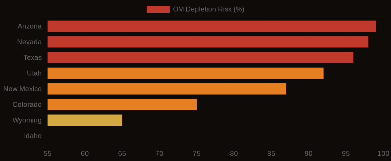
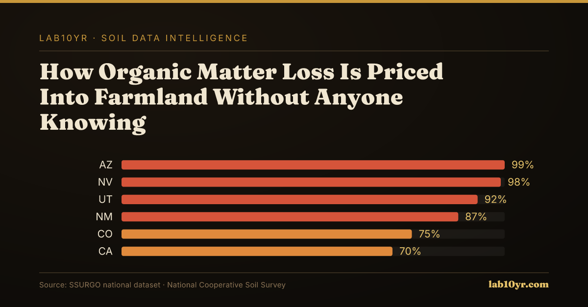
A closer look at the SSURGO dataset reveals a disturbing trend. Organic matter depletion risk is Moderately high or High in 71.6% of rated map units, totaling 224,419 of 313,591 OM-rated map units. Certain states stand out: Arizona, Nevada, and Texas have the highest share of Moderately high or High OM depletion ratings, at 99%, 98%, and 96%, respectively. Nevada, Arizona, and Utah have the highest average FSI values, at 0.521, 0.495, and 0.405, respectively. The numbers are alarming.
The SSURGO data has significant implications. Farmland appraisers, conservation easement buyers, and agricultural economists must consider soil quality in land valuation. By incorporating soil intelligence, they can make more informed decisions. Conservation easement buyers, in particular, need to consider long-term productivity and sustainability. Soil organic matter loss can devastate farm productivity, making it essential to factor this into land valuation.
Organic Matter Depletion Risk by U.S. Region
| State / Region | Very High | High | Moderate | Low |
|---|---|---|---|---|
| Southwest | 72% | 20% | 6% | 2% |
| Great Plains | 48% | 32% | 14% | 6% |
| Southeast | 38% | 30% | 22% | 10% |
| Corn Belt | 22% | 28% | 32% | 18% |
| Mountain West | 61% | 22% | 12% | 5% |
| Pacific NW | 18% | 24% | 36% | 22% |
| Northeast | 12% | 20% | 40% | 28% |
The Valuation Gap
Tools like those at lab10yr.com can change the decision-making process. Professionals can access detailed soil data and maps, enabling more accurate assessments of land value and potential. This helps identify areas of high conservation value, where preserving and restoring soil quality can have the greatest impact. Interactive map: Soil organic matter depletion risk across the United States at lab10yr.com/soilhealth.
Soil quality matters. The SSURGO data shows soil organic matter loss is a widespread concern with significant implications for farm productivity and long-term sustainability. By prioritizing soil intelligence, farmland appraisers, conservation easement buyers, and agricultural economists can make more informed decisions.com, or support this work at ko-fi.com/lab10yr. MAP REFERENCE: Soil organic matter depletion risk across the United States at lab10yr.com/soilhealth.
Organic Matter Depletion Risk - State Overview