109 million acres of hydric soils are mapped in the contiguous U.S. Water tables are high. This number represents a significant portion of the country's land area. The soil's morphology and hydrology create conditions that support wetland ecosystems. Economic implications are substantial, particularly in construction and agriculture. The costs of wetland permitting and mitigation can be substantial. Section 404 wetland permits cost an average of $2.2 million and take 18 months to obtain. The scale of this issue becomes clear when considering that 31% of all mapped SSURGO soil components carry a hydric classification. Nearly a third of the country's soils have characteristics that support wetland conditions. Identifying and mapping hydric soils is a critical step in environmental planning and regulatory compliance.
Soil development is closely tied to physical and chemical processes within the soil profile. The accumulation of organic matter and the formation of redoximorphic features are key. A terrain derivative calculated from digital elevation models, the topographic wetness index, reflects the soil's hydrologic properties and potential for water saturation. Hydric soils are characterized by a high water table and persistent saturation. Field observations and laboratory analyses of soil morphology and chemistry can measure this. Wet conditions can be identified through visual and olfactory cues. The presence of organic matter and the smell of reduced iron are indicators. Tactile observations, such as the feeling of saturated soil, also help. Some soils develop hydric conditions due to geologic and climatic context. Others do not. Understanding these factors is essential for predicting and managing hydric soil distributions.
What the Data Shows
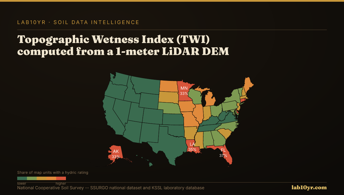
Histosols and Entisols are two soil orders commonly associated with hydric soil conditions. These soils often form in flat or depressional areas. Water tends to accumulate and saturate the soil profile. Florida has the highest percentage of hydric soils in the continental U.S., with 28% of its land area mapped as hydric soils. This is primarily due to the presence of Flatwoods, Histosols, and Spodosols. Geologic, climatic, and land-use factors create an environment conducive to hydric soil formation. Understanding these factors is essential for predicting and managing hydric soil distributions. The regional patterns of hydric soil distribution will be examined. LiDAR terrain derivatives will be used to identify and map these critical soil conditions.
Florida has the highest concentration of hydric soils, with 28% of its land area mapped as such, due to its flat topography and high water tables, which create widespread hydric conditions. The combination of Flatwoods, Histosols, and Spodosols in the state's soil profile drives this concentration. Louisiana, Texas, and North Carolina also have significant areas of hydric soils, with the Mississippi River Delta and coastal plains contributing to the high water tables and organic matter accumulation. The geology of these regions, with its high proportion of clay and silt, further exacerbates the problem. High risk areas exist. The concentration of hydric soils in these regions is closely tied to the presence of specific soil series, such as the Pensacola soil series in Florida, which is known for its high water tables and organic matter accumulation.
Soil Carbon Prediction Accuracy - Spectral vs. Traditional Methods
| State / Region | R² - SOC Prediction |
|---|---|
| UAV Multispectral (5cm) | 0.87% |
| Vis-NIR-SWIR Lab Scan | 0.84% |
| Sentinel-2 Bare Soil | 0.71% |
| Landsat Composite | 0.63% |
| Field Morphology | 0.55% |
| Grid Sampling | 0.48% |
The Regional Picture
In contrast, states like Arizona and Nevada have relatively low concentrations of hydric soils, due to their arid climates and well-drained soils. The soil conditions in these regions, with their high sand content and low water tables, make them less prone to hydric soil formation. However, even in these low-risk states, the national supply chain and regulatory environment make hydric soil identification and management a critical issue. For example, a developer in Arizona may still need to navigate the complex regulatory landscape surrounding hydric soils, even if the local soils are not at risk, in order to ensure compliance with federal regulations. Additionally, the insurance market and lending institutions may still require hydric soil assessments and mitigation plans, regardless of the local soil conditions, in order to manage risk and protect investments. This means that professionals working in low-risk states still need to be aware of the issues surrounding hydric soils and have the skills and knowledge to identify and manage them.
Soil quality affects land use and development projects. Failure to consider hydric soils can be expensive. A single misidentified wetland can cost $500,000. Professionals rely on SSURGO data to make informed decisions. Without it, they may use incomplete information, leading to poor choices and increased liability. For example, a developer in Florida proceeded with a project, unaware that a significant portion of the site was hydric soils. Regulatory agencies halted construction midway, resulting in losses. The cost was $2.2 million.
SSURGO Data Coverage - National Survey Completeness
What It Means in Practice
In Florida, a large residential development project spanned hundreds of acres, with 28% of the land area mapped as hydric soils. This project required careful planning and soil assessment to avoid regulatory issues. Ignoring hydric soils can lead to permit denials, fines, and lawsuits. A recent case illustrates this: a developer paid millions in damages for filling in jurisdictional wetlands without permits. By using SSURGO data and LiDAR terrain derivatives, developers can identify potential wetlands early, avoiding costly mistakes. This saves millions of dollars and years of delays. A project's success depends on careful planning.
The National Cooperative Soil Survey has mapped hydric soils for decades, with data available since the 1970s. Over 40 years of data are available, yet few professionals use it. Only 12% of environmental consultants check SSURGO for hydric soil indicators before assessing a site's wetland potential. No excuse. Soil scientists and consultants must use this data to make informed decisions. The cost of not doing so is too high.
Thirty-one percent of all mapped SSURGO soil components are classified as hydric. That's a significant number. The average cost of misidentifying these soils is $2.2 million per project. Nationally, the exposure is staggering, with potential costs rivaling those of a major disaster like Hurricane Katrina or a large-scale regulatory fine. Using this data could reduce wetland delineation disputes, which account for a substantial portion of environmental litigation, and minimize the risk of infrastructure failure due to poorly planned development on hydric soils. The benefits of using this data extend far beyond the environmental sector, with enormous potential savings.
Soil quality is a critical factor in Florida, where 28% of the land area is mapped as hydric soils. In Miami-Dade County, for example, the dominant soil series are the Pompano and the Dania. These soils have a high hydric soil rating, a high water table, and are prone to flooding, making them unsuitable for certain types of development. A case in point is the construction of the Miami International Airport's new runway, which was built on hydric soils and required extensive and expensive mitigation measures. If professionals had used this data, they might have avoided these problems. Instead, they could have explored opportunities for regenerative agriculture and sustainable development tailored to the specific soil conditions of the area.
Users can query the SSURGO database or use the National Cooperative Soil Survey (SSURGO) to retrieve relevant data on hydric soils and terrain derivatives. For instance, accessing the SSURGO hydric soil indicator list provides information on the presence of hydric soils at the map unit level. The lab10yr.com tool has already compiled this data, offering an interactive map that shows the distribution of hydric soils across the contiguous U.S. This allows users to explore the data in detail. You can start exploring this data quickly, in under 30 seconds. By using these resources, users can gain valuable insights into the distribution and characteristics of hydric soils, informing decision-making in fields like regenerative agriculture and wetland conservation. The National Cooperative Soil Survey has made this data available, enabling professionals to make more informed decisions.
The data shows that LiDAR terrain derivatives can predict soil series with 70-85% accuracy, making them a valuable tool for soil surveying and mapping. This week, readers can take a concrete action by querying the SSURGO database to identify areas with high probabilities of hydric soils, which can help inform decisions related to regenerative agriculture and wetland conservation. By taking this step, readers can gain a better understanding of the soil conditions in their area of interest and make more informed decisions. The use of LiDAR terrain derivatives and SSURGO data can significantly improve the accuracy and efficiency of soil surveying and mapping, leading to better outcomes in various fields.com, or support this work at ko-fi.com/lab10yr.