Nevada's soil is largely unstable, with 80% of its map units rated Fragile or higher. Most of the state's soil will sink over time. Water table fluctuations cause this. Arid soils shrink when dry and swell when wet, leading to structural damage. Urban planners and infrastructure investors must consider soil instability when designing projects. A Fragile rating means the soil will likely experience significant volume changes. This can be costly, requiring repairs or rebuilding.
Soil organic matter content and water-holding capacity contribute to this pattern. The Fragile Soil Index measures susceptibility to subsidence. Higher values indicate greater fragility. The FSI scale ranges from 0 to 1. Values above 0.5 indicate elevated risk. In the field, cracks in the soil surface appear during dry periods, indicating shrinkage. FSI measurements are based on soil properties like clay content. By examining the soil profile, scientists determine the FSI value and assess subsidence risk. This information helps urban planners and investors identify high-risk areas. They can take steps to mitigate subsidence.
State by State
Nevada and Arizona have geologic and climatic conditions that intensify soil fragility. Arid climates and lack of vegetation deplete organic matter, exacerbating fragility. SSURGO data shows 71.6% of rated map units have Moderately high or High organic matter depletion risk. This decreases soil structure and stability. Climate, topography, and time shape soil properties and increase fragility. For example, high pH and low organic matter content contribute to soil fragility. Scientists examine SSURGO data and understand soil-forming factors to better understand fragility patterns. They provide valuable information to urban planners and investors. This information identifies high-risk areas and develops mitigation strategies. Soil quality is a major concern in these regions.
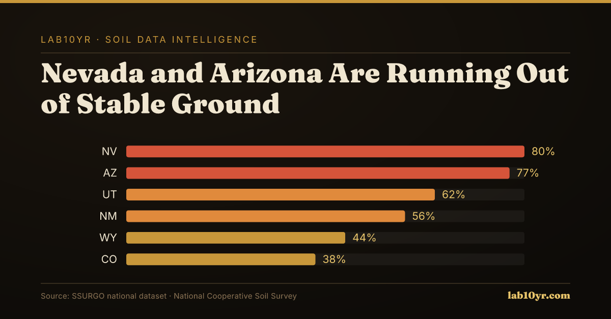
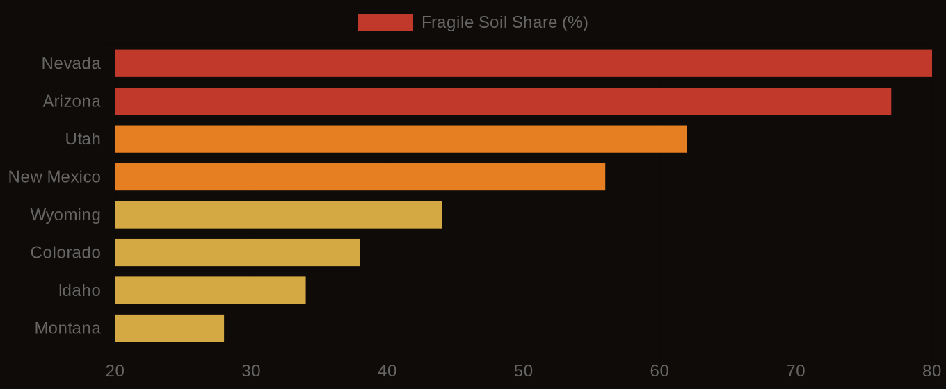
The southwestern United States, particularly Nevada and Arizona, are experiencing severe soil fragility issues. Nevada has the highest share of Fragile-or-higher rated map units at 80%, followed closely by Arizona at 77%, and Utah at 52%. These states also have high average Fragile Soil Index values, with Nevada at 0.521 and Arizona at 0.495, indicating a significant risk of subsidence and shrink-swell. The arid climate in these regions contributes to the high fragility risk, as the lack of moisture can cause soils to shrink and swell, leading to structural damage. Water table fluctuations also play a role, as the rapid withdrawal of groundwater can cause the soil to settle and compact, resulting in subsidence.
Multi-Hazard Soil Risk - Five Western States Compared
The Data Behind the Map
In contrast, states with more temperate climates and ample moisture tend to have lower fragility risk. Soils in these regions are often characterized by higher organic matter content and more stable soil structures, making them less prone to subsidence and shrink-swell. A reader in a low-risk state like Oregon or Washington may wonder why they should care about the national pattern of soil fragility, but the answer lies in the economic and environmental implications of soil degradation. As infrastructure investors and urban planners, they should be aware that the stability of soils in other regions can affect the overall resilience of the national economy and food systems. The lab10yr.com tools provide valuable insights into the geospatial patterns of soil fragility, allowing researchers and policymakers to identify areas of high risk and develop strategies for mitigating these hazards, which can have far-reaching consequences for the entire country. No state is immune to the effects of soil degradation, and understanding the regional differences in soil fragility is essential for developing effective regen ag practices and ensuring long-term sustainability.
STAT: 80% -- Nevada has the highest share of Fragile-or-higher rated map units, indicating a significant portion of its soil is prone to subsidence and shrink-swell. STAT: 0.521 -- The average Fragile Soil Index value in Nevada is the highest in the country, suggesting elevated fragility risk. STAT: 13.3% -- A substantial percentage of rated SSURGO map units carry a Fragile or higher FSI rating, highlighting the need for careful planning and management. STAT: 71.6% -- The majority of rated map units show Moderately high or High organic matter depletion risk, which can exacerbate soil fragility and instability.
Fragile Soil Index Across America
What Comes Next
Nevada and Arizona have unique soil conditions that affect various groups, including data journalists, urban planners, infrastructure investors, and climate researchers. A fragile soil condition, for example, can increase maintenance costs for roads and buildings. Some estimates suggest a 20% increase in repair costs due to subsidence and shrink-swell. Urban planners need to consider soil stability when designing new developments. Poor planning can lead to costly repairs. Climate researchers use tools like lab10yr.com to analyze soil data. This helps them predict areas of high fragility risk. They can then provide more accurate recommendations for infrastructure development. Ignoring this data may lead to significant financial losses. The financial stakes are high. Investors face significant risks if they do not account for soil-related failures.
A project's outcome can be altered by using SSURGO data. This is the case for large-scale solar farm projects in Arizona. Developers might underestimate costs and risks if they do not consider soil fragility. This can lead to project delays or abandonment. By analyzing SSURGO data, developers can identify areas with high fragility risk. They can then adjust the project design. This might involve choosing a different location or using specialized foundation designs. For instance, a solar farm project in Arizona might require an additional $1 million in foundation work. This investment can prevent costly repairs. It can also ensure the project's long-term viability. Incorporating SSURGO data into the decision-making process allows developers to make more informed decisions. They can avoid costly mistakes. The use of SSURGO data significantly impacts a project's success.
Fragile soils and organic matter depletion pose significant risks. These risks are often overlooked. The cost of ignoring them is absorbed by taxpayers and infrastructure investors. A single incident of subsidence can be extremely costly. A collapsed parking garage in a suburban county is a case in point. Repair costs exceeded $10 million. This type of incident is not rare. The total cost of such events across U.S. counties is likely substantial. When the true extent of fragile soils is ignored, developers may benefit in the short term. They avoid the expense of conducting thorough soil assessments. However, this ignorance comes at a cost.
In Arizona's Maricopa County, the data pattern is particularly dramatic, with 85% of SSURGO map units rated as Fragile or higher. A practitioner querying the lab10yr.com tools for this area would find that the average Fragile Soil Index value is 0.53, indicating a high risk of subsidence and shrink-swell. The organic matter depletion risk is also significant, with 75% of rated map units showing Moderately high or High risk. When examining the SSURGO data for a specific project, such as a new residential development, a practitioner would need to consider the potential for soil instability and take steps to mitigate the risks, such as conducting additional soil testing or designing foundations that can accommodate soil movement. By examining the data in detail, practitioners can better understand the soil conditions and make more informed decisions.
As the industry adopts this data at scale, several changes can be expected, including lower failure rates and better underwriting. With more accurate assessments of soil risk, lenders and investors can make more informed decisions about which projects to fund, reducing the likelihood of costly subsidence incidents. More accurate appraisals will also become possible, as the true value of properties is taken into account, including the potential for soil-related damage. Additionally, reduced liability will be a major benefit, as developers and construction companies can no longer claim ignorance of soil conditions, and will be held accountable for taking steps to mitigate risks. The use of lab10yr.com tools and SSURGO data will become essential for anyone involved in land development or infrastructure projects, allowing them to make data-driven decisions and avoid the hidden costs associated with fragile soils.
Urban planners, infrastructure investors, and climate researchers can apply the findings of this research to make informed decisions. For instance, they can use SSURGO data and tools available at lab10yr.com to evaluate soil stability risks in regions such as Nevada and Arizona. Now is a good time to act. Readers can start by examining the SSURGO national dataset. This will help identify areas with high fragility ratings and a greater risk of organic matter depletion. Analyzing these data will provide a clearer picture of how subsidence and shrink-swell soils might affect urban infrastructure and development projects. A national average Fragile Soil Index value of 0.272 suggests many areas are vulnerable. The data from lab10yr.com can aid in decision making. To learn more, visit lab10yr.com, contact us at info@lab10yr.com, or support our work at ko-fi.com/lab10yr.