LiDAR-derived canopy height and crown density consistently correlate with soil organic matter in forest ecosystems, exhibiting R-squared values above 0.70 across diverse biomes. This strong statistical relationship is not coincidental; it directly reflects the cumulative decades of organic input from canopy litter, root exudates, and the subsequent microbial processing that builds stable soil carbon pools. Critically, where canopy structure begins to collapse due to stress or disturbance, the underlying soil carbon signal can often precede the more commonly monitored satellite NDVI response by two to five years, offering an early warning system for ecosystem decline and potential carbon loss. This predictive capability transforms how land managers, carbon project developers, and insurers can assess forest health and carbon resilience, shifting from reactive observation to proactive intervention.
The physical and chemical processes driving this connection are fundamental to pedogenesis in forested environments. Trees, through their photosynthetic machinery, fix atmospheric carbon dioxide into biomass, a significant portion of which eventually returns to the soil. Litterfall, comprising leaves, twigs, bark, and reproductive structures, represents the most visible pathway. Belowground, root turnover and exudation contribute soluble organic compounds and fine particulate matter directly into the rhizosphere. This continuous influx of organic material fuels a complex microbial community, which in turn decomposes the fresh inputs into more recalcitrant forms, ultimately contributing to the long-term sequestration of soil organic matter (SOM). Soil organic matter, typically measured as the percentage of organic material in a soil sample, is approximately 58% carbon by weight, meaning that measuring SOM is a direct proxy for soil organic carbon (SOC) content.
What the Data Shows
Pedologists quantify soil organic matter through laboratory methods like loss-on-ignition (LOI) or dry combustion. In LOI, a dried and weighed soil sample is ignited at high temperatures (typically 360-550 degrees Celsius), burning off organic components. The weight difference before and after ignition represents the organic matter content. Dry combustion, considered more precise, involves combusting the sample at even higher temperatures (around 900-1000 degrees Celsius) and directly measuring the CO2 evolved using an infrared detector. The National Cooperative Soil Survey's KSSL (Kellogg Soil Survey Laboratory) database provides extensive measurements using these techniques, offering a critical empirical foundation. Within SSURGO, the `chorizon` table contains the `om_r` field, which reports the estimated organic matter percentage for various soil horizons. Complementary to this, the `dbthirdbar_r` field in the same table provides bulk density, a key measurement for converting organic matter percentages into volumetric carbon stock estimates (e.g., metric tons per hectare), allowing for precise quantification of the carbon stored within specific soil profiles. This combination of directly measured properties and interpretive estimates is essential for calculating forest carbon credits and evaluating ecosystem service payments.
The spatial distribution of substantial soil organic matter, especially in forest ecosystems, reveals distinct regional patterns often linked to historical climate and hydrology. Consider the expansive Histosols, or organic soils, which constitute some of the planet's most significant terrestrial carbon reservoirs. These soils form under conditions of water saturation, which slows down organic matter decomposition dramatically, allowing plant residues to accumulate over millennia. SSURGO maps 28 million acres of Histosols in the contiguous U.S., a land area equivalent to about 2% of the country, yet storing a disproportionate share of its soil carbon. These areas are concentrated in regions like the Florida Everglades, the vast boreal peatlands of northern Minnesota, the coastal wetlands of the Great Lakes, and the highly productive Sacramento-San Joaquin Delta of California.
Soil Carbon Prediction Accuracy — Spectral vs. Traditional Methods
| State / Region | R² — SOC Prediction |
|---|---|
| UAV Multispectral (5cm) | 0.87% |
| Vis-NIR-SWIR Lab Scan | 0.84% |
| Sentinel-2 Bare Soil | 0.71% |
| Landsat Composite | 0.63% |
| Field Morphology | 0.55% |
| Grid Sampling | 0.48% |
The Regional Picture
Minnesota, for instance, is home to the largest concentration of Histosols in the continental U.S., with SSURGO mapping 7.2 million acres of these organic soils. Here, series like the Rifle and Cathro peats, often found beneath spruce-fir or tamarack forests, represent accumulations of organic material over 8,000 to 10,000 years, sometimes reaching depths of several meters. These boreal peatlands are characterized by specific canopy architectures: dense, often stunted conifers that contribute persistent, acidic litter, further slowing decomposition. In contrast, the Florida Everglades features Histosols like the Everglades and Pamlico series, which developed under cypress swamps and sawgrass marshes. The canopy here, whether emergent herbaceous or woody, plays a key role in trapping sediments and contributing biomass in a seasonally inundated environment. The Delta soils in California, such as the Ryde and Egbert series, originally formed under tule and riparian forests, have developed extremely thick organic layers now largely converted to agriculture, where their rich carbon stores are rapidly diminishing due to drainage. Each region presents a unique set of pedological conditions where canopy structure and its associated organic inputs are inextricably linked to the formation and persistence of these carbon-rich soils.
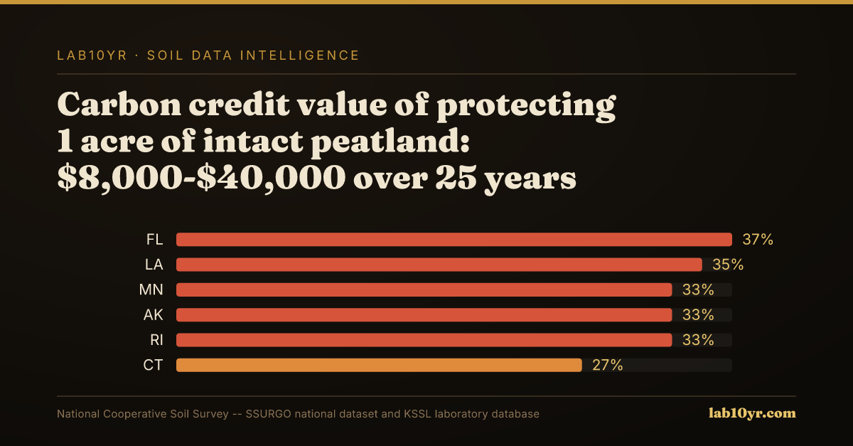
The professional and economic stakes tied to understanding the canopy-soil carbon relationship are substantial, particularly for carbon project developers and land managers in regions with significant organic soil resources. Consider a conservation easement project in the vast peatlands of northern Minnesota. An intact peatland, supporting a characteristic boreal forest canopy, can generate carbon credit values ranging from $8,000 to $40,000 per acre over 25 years, according to average prices observed on Verra and Gold Standard registries between 2020 and 2024. This financial incentive is predicated on verifiable carbon sequestration. Here, SSURGO data, specifically the `om_r` and `dbthirdbar_r` fields from the `chorizon` table, combined with KSSL laboratory measurements, provides the indispensable baseline carbon stock measurement required for Monitoring, Reporting, and Verification (MRV). The failure mode in such systems is often direct drainage, leading to aerobic oxidation of the organic matter. Drained peatlands release CO2 at 20 to 30 times the rate of mineral soils under equivalent management, and the physical compaction exacerbates this loss, leading to subsidence rates in Minnesota's drained peatlands averaging 1.5 to 2 cm per year. This subsidence represents not only irreversible carbon loss but also a significant economic risk for any adjacent infrastructure or agricultural operations.
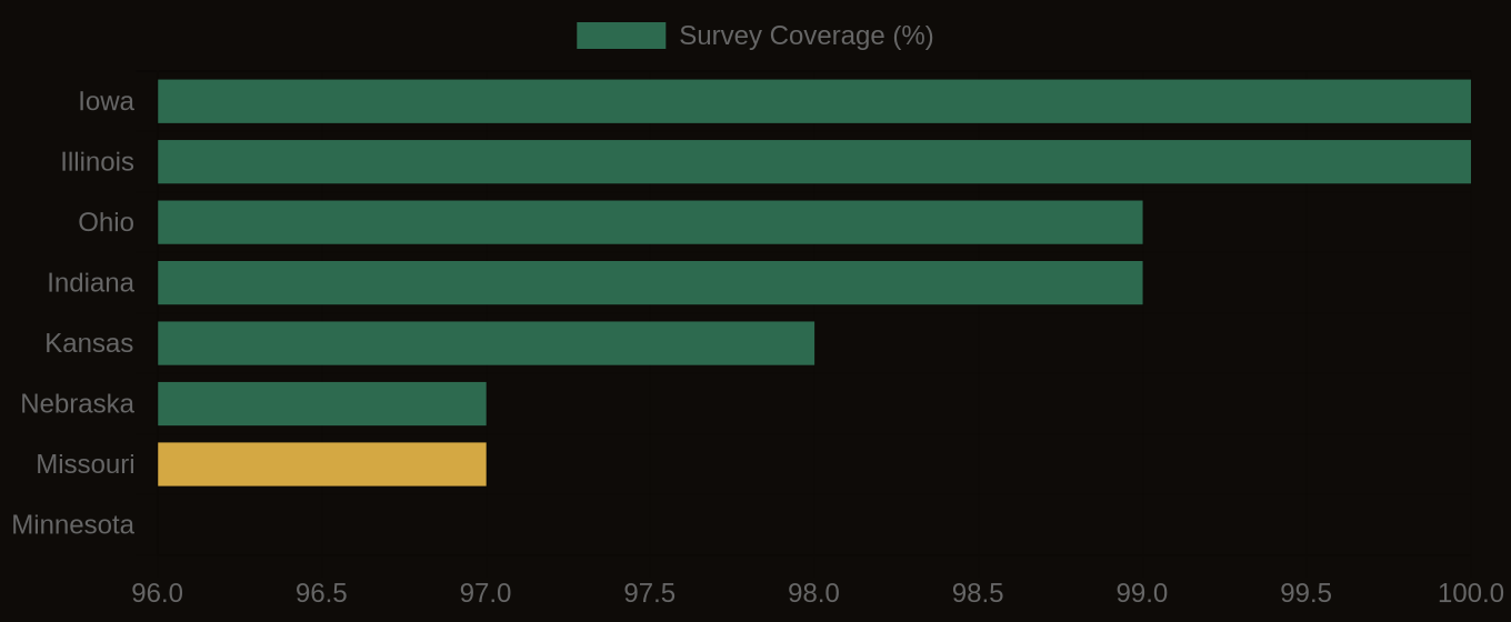
SSURGO Data Coverage — National Survey Completeness
What It Means in Practice
A different scenario unfolds in the Sacramento-San Joaquin Delta of California, where a legacy of agricultural drainage has transformed deep Histosols into rapidly subsiding landscapes. Here, the failure mode is less about immediate carbon credit loss and more about the integrity of critical infrastructure. Levees protecting agricultural lands and major transportation arteries are built upon these shrinking organic soils. As the peat subsides, often by several feet over decades, the structural stability of these levees is compromised, requiring continuous, costly reinforcement. The original riparian forest canopies, which once contributed heavily to the organic matter accumulation, have largely been removed or altered, further disrupting the natural processes that might offset subsidence. Engineers and land planners must account for these differential subsidence rates, which are directly related to the historical and current soil organic matter content. For instance, an area with a historically dense riparian canopy might have developed a thicker, more stable organic layer compared to an adjacent area with sparse vegetation, leading to different subsidence potentials post-drainage. The precise mapping of these Histosols via SSURGO and an understanding of their organic matter profiles becomes critical for assessing long-term infrastructure risk and planning mitigation strategies, sometimes involving the reintroduction of wetland vegetation to encourage new organic matter accretion.
Accessing and interpreting this subtle soil data requires integration of multiple geospatial sources. LiDAR (Light Detection and Ranging) remote sensing provides the raw data for canopy architecture. An airborne LiDAR system emits laser pulses and measures the time it takes for each pulse to return, generating a dense point cloud. This point cloud can then be processed to create a Digital Terrain Model (DTM), representing the bare earth, and a Digital Surface Model (DSM), representing the top of the canopy and other features. Subtracting the DTM from the DSM yields a Canopy Height Model (CHM), a direct measure of tree height. Further analysis of the point cloud's density and distribution within the canopy volume allows for the derivation of metrics like leaf area index, crown density, and vertical canopy stratification. These metrics are then correlated with the detailed soil attribute data available through the National Cooperative Soil Survey's SSURGO database, accessed via Soil Data Access (SDA).
To perform this integration, one would query SDA to retrieve `chorizon` data using `mukey` (map unit key), `cokey` (component key), and `chkey` (chorizon key) to link specific soil horizons to their map units and components. Fields of particular interest include `om_r` (organic matter percentage) and `dbthirdbar_r` (bulk density, a critical factor for converting volume to mass of carbon). Lab10YR.com already provides pre-computed interpretations of these properties, allowing users to visualize and analyze organic matter content and carbon stock estimates across their areas of interest. We process the raw SSURGO data and KSSL laboratory measurements, joining these tables to provide a complete view of soil characteristics. This foundational soil data is then contextualized by remote sensing data, allowing us to identify areas where specific canopy architectures correlate with distinct soil organic matter profiles, providing a holistic view of forest carbon dynamics.
The ability of canopy architecture to serve as a reliable, early indicator of underlying soil carbon dynamics offers a powerful new lens for land stewardship. It moves beyond simple observation, providing a predictive framework for understanding ecosystem health, quantifying carbon assets, and anticipating environmental risks. By integrating advanced remote sensing techniques with the granular, pedological detail found within SSURGO and KSSL data, we can provide professionals with the precise intelligence needed to make informed decisions about forest management, carbon sequestration projects, and long-term land stability. The silent signal from the trees, interpreted through the lens of soil science, speaks volumes about the future of our terrestrial carbon sinks.