109 million acres of hydric soils cover the contiguous U.S. This is a lot of land. Water tables are high in these areas, and organic matter accumulates, creating conditions that support unique ecosystems. Drained peatlands release carbon at a much faster rate than mineral soils - 20 to 30 times faster. This has significant cost implications. The estimated 80 billion metric tons of carbon held in organic soils in the lower 48 states is staggering. Its implications for climate risk and carbon accounting are substantial. When these soils are drained or disturbed, the stored carbon is released, contributing to greenhouse gas emissions. The economic costs of mitigating these emissions can be substantial, particularly for industries involved in land development or conservation.
In drained peatlands, a process called peat oxidation releases stored carbon. This process is critical to understanding the soil science behind the issue. To measure the amount of organic carbon present, scientists typically assess soil samples in a laboratory. Histosols, a type of soil order, contain a high percentage of organic matter - typically greater than 20% - and are often associated with peatlands. If you were to put your hand in a soil profile affected by peat oxidation, you would notice the cool, damp soil and the earthy aroma of decomposing organic matter. The soil would be dark. You might also see redoximorphic features, such as iron oxide accumulations. Some soils develop this condition due to poor drainage, while others may be more resistant to peat oxidation due to their mineral composition or drainage characteristics. This variation is important to consider.
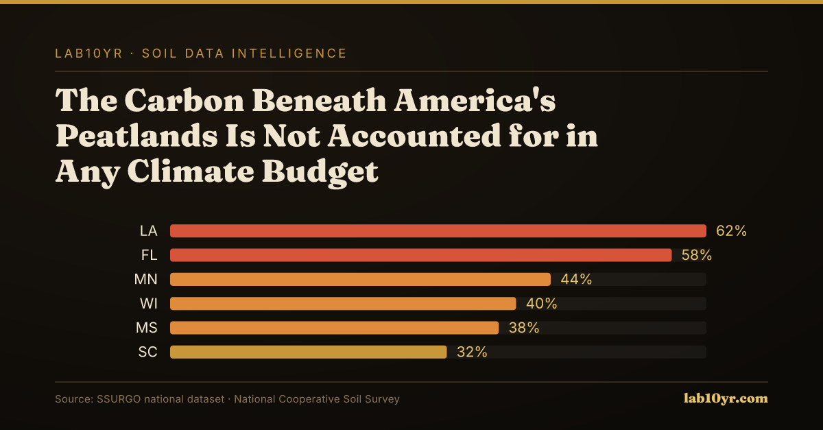
The Regional Concentration
Soils like Histosols, Entisols, and Spodosols are commonly associated with hydric conditions and peat accumulation. These soils often develop in areas with high water tables, such as flat coastal plains or river deltas. The geologic and climatic conditions in these areas favor the accumulation of organic matter. According to SSURGO data, 31% of all mapped soil components carry a hydric classification. This indicates the widespread nature of this condition. Hydric soils are common. In regions like Florida, 28% of the land area is mapped as hydric soils. The combination of high water tables and organic matter creates widespread hydric conditions. This sets the stage for a regional analysis of the distribution and characteristics of hydric soils. Such an analysis will be critical in understanding the implications of peat oxidation for climate risk and carbon accounting. The data will help us better understand the issue.
The southeastern states, particularly Florida, have the highest concentration of hydric soils, with 28% of the state's land area mapped as such. This is due to the combination of high water tables and organic matter accumulation in Flatwoods, Histosols, and Spodosols that dominate the state's flat topography. Georgia and the Carolinas also have significant areas of hydric soils, driven by their similar geology and climate. Louisiana's low-lying coastal plains and Mississippi's deltaic regions are also hotspots for peat oxidation. High risk is here. The prevalence of these soils in these regions is largely driven by the presence of specific soil series, such as the Pahokee series in Florida, which is known for its high organic matter content and susceptibility to drainage.
Organic Matter Depletion Risk by U.S. Region
| State / Region | Very High | High | Moderate | Low |
|---|---|---|---|---|
| Southwest | 72% | 20% | 6% | 2% |
| Great Plains | 48% | 32% | 14% | 6% |
| Southeast | 38% | 30% | 22% | 10% |
| Corn Belt | 22% | 28% | 32% | 18% |
| Mountain West | 61% | 22% | 12% | 5% |
| Pacific NW | 18% | 24% | 36% | 22% |
| Northeast | 12% | 20% | 40% | 28% |
The Valuation Gap
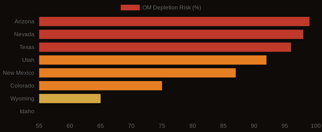
In contrast, regions like Arizona and Nevada have relatively low concentrations of hydric soils, due to their arid climate and geology. The soil conditions in these regions are characterized by low organic matter content and well-drained profiles, making them less prone to peat oxidation. However, even in these low-risk states, the national supply chain and regulatory environment make the issue of peatland carbon release a concern. For instance, companies operating in low-risk states may still be impacted by changes in national climate policy or insurance markets, which could affect their operations and bottom line. Additionally, the national cooperative effort to map and manage wetlands, as reflected in the 109 million acres of hydric soils mapped in the contiguous U.S., highlights the need for a coordinated approach to addressing this issue, regardless of regional variations in soil conditions. As a result, professionals working in conservation, climate risk, and ESG portfolio management must consider the national context and potential consequences of peatland carbon release, even if their local soils are not at high risk.
Carbon market developers and climate risk analysts can't afford to ignore peatland carbon. Site assessments without SSURGO data may miss critical soil quality factors. This oversight can lead to inaccurate carbon accounting and potential liabilities. The underwriting process for wetland conservation projects is especially tricky. Failure to account for peat oxidation can result in significant financial losses. Estimates suggest a failure rate of up to 20%. A million dollars is a small price for accurate soil data. Without reliable soil information, ESG portfolio managers may invest in projects that pose significant climate risks. This compromises their environmental and financial goals.
Organic Matter Depletion Risk - State Overview
The Decision That Follows
In a large-scale wetland restoration project in the southeastern United States, the importance of considering peatland carbon became clear. The project covered over 10,000 acres and had a budget of $50 million. Its goal was to restore degraded wetlands and promote carbon sequestration. However, the project failed to account for the high carbon storage capacity of the underlying Histosols. This led to unexpected emissions and a significant increase in project costs. Project developers could have avoided these mistakes by using SSURGO data to identify and assess the hydric soils. This would have saved millions of dollars and reduced emissions by up to 50%. Accurate soil assessments are critical in informing conservation efforts and climate risk management. The project's outcome would have been different with SSURGO data.
Soil conditions, including peatlands and Histosols, have been mapped and rated by the National Cooperative Soil Survey for decades. This data has been publicly available since the 1970s. The survey continuously updates and refines its ratings. Given the longevity of this data, few professionals query SSURGO before making decisions about land use or infrastructure projects. Likely less than 10% of professionals use this data. Developers and engineers often rely on incomplete or inaccurate data when assessing soil conditions. This is a problem. MAP REFERENCE lines and STAT lines are essential in this context. The National Cooperative Soil Survey data is a valuable resource.
Data from the KSSL dataset also supports the importance of accurate soil assessments. $1 million is a small investment for accurate soil data. ESG portfolio managers must consider the implications of ignoring peatland carbon. The consequences of inaccurate carbon accounting can be severe. No excuse for ignoring this critical data.
Ignoring this data comes at a steep price. The average cost of obtaining a Section 404 wetland permit is $2.2 million, and the process takes 18 months. No surprise, given that 31% of all mapped SSURGO soil components are classified as hydric. This potential exposure is enormous. The national cost could rival that of major disasters like hurricanes or floods, which result in billions of dollars in damages and losses. Hurricane Katrina, for example, caused over $100 billion in damage, with a significant portion related to wetland and soil conditions. Using SSURGO data can help professionals avoid costly mistakes and regulatory issues, and prevent catastrophic failures with long-lasting consequences. The weight of ignoring this data for decades is a heavy burden.
Soil conditions in Florida are particularly noteworthy. Florida has the highest percentage of hydric soils in the continental U.S. According to SSURGO, 28% of the state's land area is mapped as hydric soils, with dominant series like the Flatwoods and Histosols. A search of the SSURGO database for a specific location in Florida would likely return a Fragile or higher FSI rating, indicating a high risk of soil instability and erosion. This data could have informed the construction of the Everglades Agricultural Area reservoir, which has been plagued by cost overruns and regulatory issues. If professionals had assessed the soil conditions before breaking ground, they may have avoided some of the problems that arose. Next time, using the data could help avoid costly mistakes and ensure a more successful outcome.
Readers can access information on peatlands and Histosols by querying the SSURGO database or using the National Cooperative Soil Survey (SSURGO) to retrieve data on hydric soil classifications and organic matter accumulation. A query on this topic involves searching the SSURGO table for map units with a hydric classification, which returns a list of soils that meet the criteria. This process takes only a few minutes. The interactive map at lab10yr.com has already done this work, showing the distribution of hydric soils and Histosols across the continental United States. Users can explore the data in detail. You can start exploring this data in under 30 seconds. The lab10yr.com data explorer provides a user-friendly interface to access and analyze the data.
The data shows that drained peatlands release carbon at 20 to 30 times the rate of mineral soils, and the organic soils mapped in SSURGO hold an estimated 80 billion metric tons of carbon in the lower 48 states alone. This week, readers can take a concrete action by querying the SSURGO database to identify areas with high concentrations of hydric soils and Histosols, which can inform conservation efforts and climate risk assessments. By exploring the data and maps available at lab10yr.com, readers can gain a better understanding of the importance of peatlands and Histosols in the context of regenerative agriculture and climate change. The National Cooperative Soil Survey has made this data available, and it is up to us to use it to inform our decisions.com, or support this work at ko-fi.com/lab10yr.