The Kellogg Soil Survey Laboratory (KSSL) spectral library holds a profound, yet often overlooked, resource for soil science: over 50,000 soil samples with matched Visible-Near Infrared-Shortwave Infrared (Vis-NIR-SWIR) reflectance and complete laboratory chemistry measurements. It stands as the largest publicly available soil spectral dataset in the world, a deep well of data largely untapped by many outside federal programs. This library offers a critical foundation for advancing remote sensing applications in soil characterization, particularly for critical properties like soil organic carbon.
Reflectance spectroscopy, the core technique behind the KSSL library, measures how incident light across the Vis-NIR-SWIR spectrum (approximately 350 to 2500 nanometers) interacts with the soil surface. Different soil constituents absorb and reflect light at specific wavelengths. For example, organic matter absorbs more light in the visible range and exhibits characteristic absorption features in the NIR and SWIR regions due to C-H, O-H, and N-H bonds. The KSSL dataset, housed within the National Cooperative Soil Survey's Kellogg Soil Survey Laboratory, systematically records these spectral fingerprints alongside direct laboratory measurements of soil properties like organic carbon content, particle size distribution, and mineralogy.
What the Data Shows
This direct linkage between spectral signatures and measured soil properties is invaluable for calibrating remote sensing models. For instance, bare soil Vis-NIR-SWIR reflectance consistently predicts soil organic carbon with R-squared values between 0.75 and 0.88 in the Corn Belt, as demonstrated by KSSL spectral library calibration studies. This strong relationship holds across diverse soil texture classes when models are appropriately trained with geographically matched samples. Precision agriculture technology firms can use this to refine intra-field organic matter mapping using multispectral drone imagery, which can achieve R-squared values of 0.82-0.87 from bare soil composites at 5-cm resolution, outperforming broader-scale satellite data for granular field management.
The KSSL library also contextualizes broader remote sensing efforts. While drone imagery offers high resolution, satellite platforms like Landsat provide historical depth. A bare soil composite created from 20 years of Landsat imagery, for instance, can capture stable soil spectral signals that correlate with organic matter at 30-meter resolution. This temporal compositing removes transient effects from vegetation, crop residue, and cloud cover, exposing the underlying soil spectral signature for regional carbon mapping. Even radar data contributes: Sentinel-1 SAR backscatter, operating at 10-meter resolution, detects surface soil moisture under cloud cover and at night, sensitive to volumetric water content in the top 5 cm. When combined with SSURGO available water capacity (AWC) data, this enables precise field-scale water deficit estimation.
Soil Carbon Prediction Accuracy — Spectral vs. Traditional Methods
| State / Region | R² — SOC Prediction |
|---|---|
| UAV Multispectral (5cm) | 0.87% |
| Vis-NIR-SWIR Lab Scan | 0.84% |
| Sentinel-2 Bare Soil | 0.71% |
| Landsat Composite | 0.63% |
| Field Morphology | 0.55% |
| Grid Sampling | 0.48% |
The Regional Picture
For carbon project developers, understanding and integrating the KSSL spectral library into their validation and monitoring protocols offers a pathway to more strong, data-driven assessments. The library provides the ground truth necessary to translate observed spectral variations from satellite or aerial platforms into quantitative estimates of soil carbon, enhancing the credibility and scalability of carbon accounting. For remote sensing researchers, it is a ready-made training and validation dataset, allowing for the development of more accurate and generalized predictive models across varied pedological conditions. This deep archive of matched spectral and chemical data is not merely a collection; it is a foundational asset for the next generation of soil intelligence.
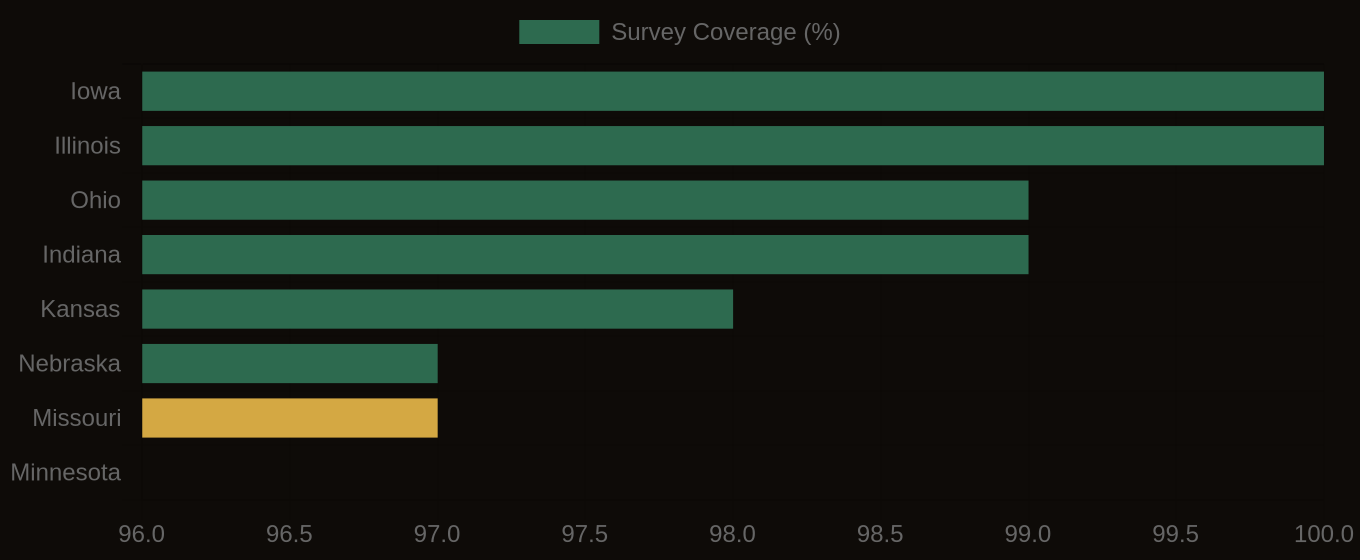
SSURGO Data Coverage — National Survey Completeness