13.3% of rated SSURGO map units carry a Fragile or higher FSI rating. This translates to 28,122 map units across the United States. The number is striking. It indicates a significant portion of the country's soil is at risk of fragility, which can lead to soil corrosivity and ultimately affect pipeline integrity. Soil corrosivity is a major concern for pipeline operators. It can cause pipeline failure, leading to costly repairs and environmental damage.
Soil corrosivity occurs when soil's chemical and physical properties interact with pipeline materials, causing corrosion and degradation. The measurement of soil corrosivity is made by assessing the soil's resistivity, which is the ability of the soil to resist the flow of electric current. Soils with low resistivity are more corrosive. Soils with high resistivity are less corrosive. The FSI rating is a key factor in determining soil corrosivity. It takes into account the soil's texture, organic matter content, and moisture levels. Soil behaves in a complex way due to its composition and structure, which is influenced by factors such as climate, geology, and land use.
Where the Risk Lives
Geographic and geologic conditions vary across the United States. Soils in arid and semi-arid regions, such as Nevada and Arizona, are more prone to fragility and corrosivity. This is due to their low organic matter content and high soil pH. In contrast, soils in humid regions, such as the Southeast, are less prone to fragility and corrosivity. They have high organic matter content and low soil pH. Specific soil series, such as the Mojave and Sonoran series, are known to have high FSI ratings. They are therefore more corrosive.
Nevada, Arizona, and Utah have the highest share of Fragile or higher rated map units. 80%, 77%, and 52% of their map units are rated as Fragile or higher, respectively. These states have the highest average FSI values. Nevada has an average FSI value of 0.521, Arizona has an average FSI value of 0.495, and Utah has an average FSI value of 0.405. The high FSI ratings in these states are due to their arid and semi-arid climates. This leads to low organic matter content and high soil pH. The soil profile in these states is characterized by low moisture levels, high soil temperatures, and low organic matter content. This contributes to their high FSI ratings. Pipeline operators in these states need to be aware of the high soil corrosivity risk. They must take necessary measures to mitigate it.
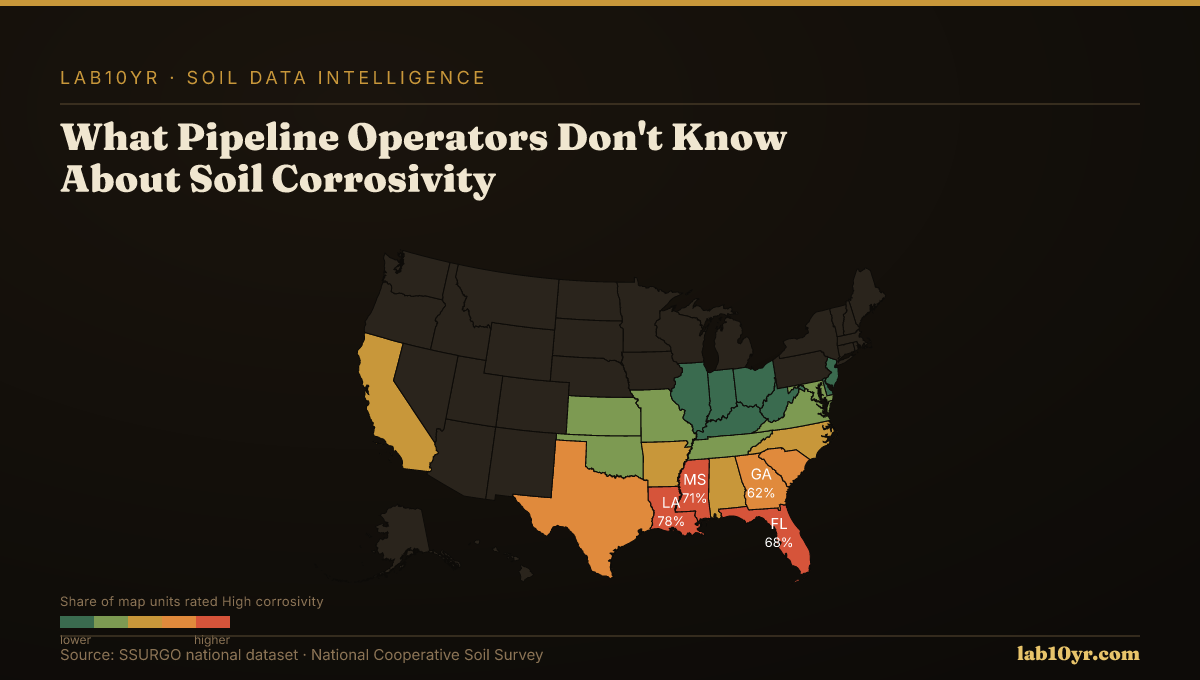
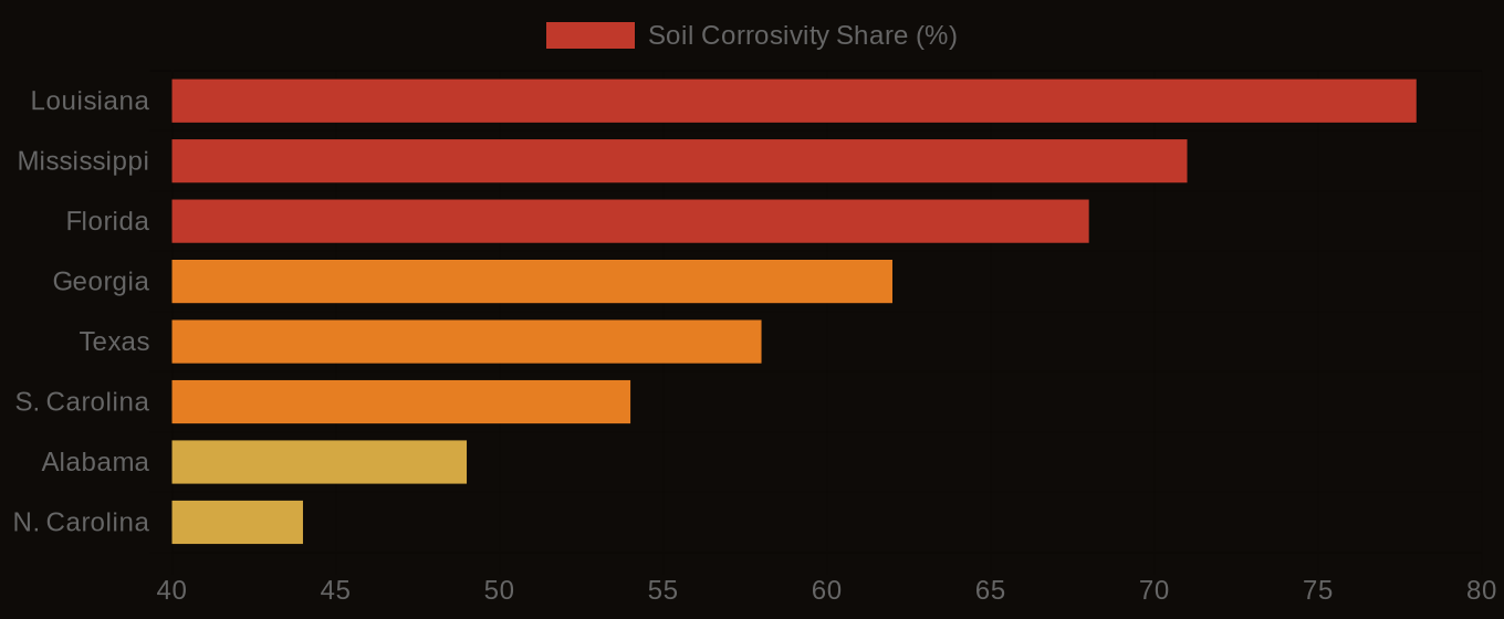
Soil Corrosivity Risk - Top U.S. Infrastructure States
| State / Region | High Corrosivity (%) |
|---|---|
| Louisiana | 78% |
| Mississippi | 71% |
| Florida | 68% |
| Georgia | 62% |
| Texas | 58% |
| S. Carolina | 54% |
| Alabama | 49% |
| N. Carolina | 44% |
| Virginia | 38% |
| Pennsylvania | 31% |
The Cost Nobody Budgets For
Soils in the Northeast and Midwest are generally more stable. They are less prone to fragility and corrosivity. This is due to their higher organic matter content and lower soil pH. However, pipeline operators in these states should not be complacent. Soil corrosivity can still occur, especially in areas with high soil moisture levels or extreme temperatures. The SSURGO dataset provides detailed information on soil properties, including FSI ratings. This information can be used to assess pipeline risk and soil corrosivity in all states.
Soil corrosivity has significant implications for pipeline operators. It can cause pipeline failure, leading to costly repairs and environmental damage. Pipeline operators need to consider soil corrosivity risk when selecting pipeline materials, designing pipeline routes, and maintaining pipeline integrity. The cost of soil corrosivity can be significant. Pipeline failures can cost millions of dollars in repairs and environmental damage. For example, a pipeline failure in a high-risk area can cost up to $10 million in repairs.
Soil Corrosivity Risk - Infrastructure Exposure by State
A Ledger the Industry Must Open
The application of soil corrosivity data can change the outcome of pipeline projects. A pipeline project in a high-risk area may require the use of more corrosion-resistant materials. The design of the pipeline route may also need to be modified to avoid areas with high soil corrosivity risk. In contrast, a pipeline project in a low-risk area may not require such measures. This can result in cost savings and reduced environmental risk. The use of soil corrosivity data can also inform the maintenance schedule of pipelines. More frequent inspections and repairs may be required in high-risk areas.
Soil corrosivity is a complex problem. Different regions and soil types pose different levels of risk. The cost of ignoring soil corrosivity data is significant. Pipeline failures and environmental damage can cost millions of dollars. The cost of soil corrosivity is borne by pipeline operators, insurers, and the environment. The failure to consider soil corrosivity data can lead to a systemic failure to mitigate pipeline risk. This can result in increased costs and environmental damage.
Nevada is a case study of soil corrosivity risk. The state has the highest average FSI value in the country. 80% of its map units are rated as Fragile or higher. The soil profile in Nevada is characterized by low moisture levels, high soil temperatures, and low organic matter content. This contributes to its high FSI ratings. Pipeline operators in Nevada need to be aware of the high soil corrosivity risk. They must take necessary measures to mitigate it, such as using corrosion-resistant materials and modifying pipeline routes.
The example of Nevada can be extended to other states and regions. Pipeline operators must consider soil corrosivity risk in their design, construction, and maintenance activities. The use of soil corrosivity data can inform pipeline risk assessment and mitigation strategies. This can reduce the cost of pipeline failures and environmental damage. The SSURGO dataset provides detailed information on soil properties, including FSI ratings. This information can be used to assess pipeline risk and soil corrosivity. By using this data, pipeline operators can make informed decisions about pipeline design, construction, and maintenance. This can reduce the risk of pipeline failures and environmental damage.
Soil corrosivity is a significant risk factor for pipeline operators. The use of soil corrosivity data can inform pipeline risk assessment and mitigation strategies. Pipeline operators can take concrete action this week by querying the SSURGO dataset for their area of operation. They can assess soil corrosivity risk. Contact us at info@lab10yr.com, explore the data at lab10yr.com, or support this work at ko-fi.com/lab10yr. The risk of soil corrosivity is real. It must be addressed.