A single turbine foundation failure costs more than a full soil survey of the wind farm site. The survey almost never happens. A 3-megawatt machine on a cracked or tilting gravity base means a crane mobilization, an excavation back down to bearing soil, a redesigned footing, and weeks of lost generation against a power purchase agreement that does not pause for geotechnical surprises. The repair routinely clears a million dollars. The soil data that would have flagged the problem before the layout was finalized is free, public, and already mapped for nearly every acre of every wind corridor in the country.
Start with what a turbine foundation actually has to do. A modern utility-scale turbine is an inverted pendulum: a nacelle and rotor weighing 70 to 100 tons sitting atop a tower 90 to 120 meters tall, with the wind pushing on the swept area of the blades. The governing load on the foundation is not the dead weight of the machine. It is the overturning moment, the bending force the wind transmits down the tower into the base. The standard answer is a gravity spread footing, an octagonal or circular reinforced concrete mat 18 to 25 meters across, buried a few meters down and backfilled, that resists tipping by sheer mass and footprint. That mat works only if the soil beneath it does two things: carry the bearing pressure without shearing, and settle uniformly rather than tilting.
What the Data Shows
Differential settlement is the failure mode that soil science predicts and that engineers fear most. Because the structure is so tall, a tiny rotation at the base becomes a large displacement at the top. A foundation tilt of one part in 200, a few millimeters of differential settlement across the mat, throws the nacelle off plumb by half a meter and loads the drivetrain and bearings in ways they were never designed for. Turbine suppliers commonly cap allowable base rotation near three millimeters per meter for the operating life of the machine. Meeting that tolerance is a soil problem first and a concrete problem second.
Two soil behaviors break the tolerance. The first is expansion, the shrink and swell of clays that contain smectite minerals. When these clays wet, the mineral lattice draws water between its sheets and the soil expands; when they dry, it contracts and cracks. The measured property is linear extensibility, reported in SSURGO as the percent change in length of a soil clod between moist and dry, stored in the field named lep in the horizon table. A soil with linear extensibility above six percent is rated high shrink-swell, and under a foundation it produces seasonal heave and slump that no amount of reinforcing steel will hold still. The second behavior is compression, the slow consolidation of soft, water-saturated, or organic-rich soils as the load squeezes water out of the pore space over months and years. Recent alluvium, glacial lake clays, and buried mucks all consolidate under sustained load, and they rarely consolidate evenly across a 20-meter mat.
Soil Drainage Suitability - Top Wind & Solar States
| State / Region | Well/Exc. Drained (suitable) | Mod. Well Drained (marginal) | Poorly Drained (unsuitable) |
|---|---|---|---|
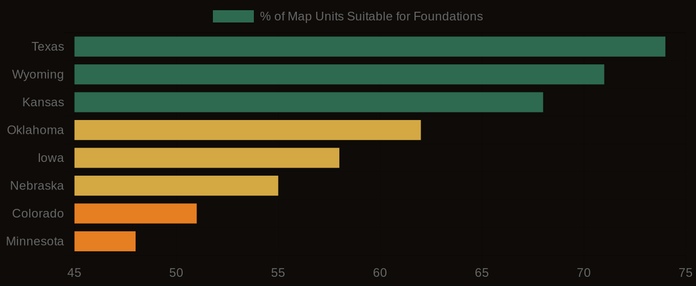
| Texas | 74% | 13% | 13% |
| Wyoming | 71% | 14% | 15% |
| Kansas | 68% | 15% | 17% |
| Oklahoma | 62% | 18% | 20% |
| Iowa | 58% | 22% | 20% |
| Nebraska | 55% | 20% | 25% |
| Colorado | 51% | 20% | 29% |
| Minnesota | 48% | 24% | 28% |
Where Exposure Is Highest
This is where drainage class becomes a fast, defensible first screen. SSURGO assigns every soil component a drainage class in the field drainagecl, from excessively drained through well drained down to poorly and very poorly drained. The class is a record of how long, in a normal year, the soil sits saturated. It is a proxy with real geotechnical meaning: well-drained soils tend to be firm, granular or loamy, and predictable in bearing; poorly drained soils signal a high water table, soft saturated horizons, and the compressible or expansive materials that drive settlement risk. Across the SSURGO national dataset, 61 percent of map units rate well drained or excessively drained, which is one reason most wind sites in the dry interior West and southern Plains carry turbine loads with standard spread footings.
The regional pattern follows the geology. In Texas, 74 percent of map units in the prime wind corridors rate well drained or better, the deep loamy soils of the southern High Plains built on caliche and old eolian sediment that take a gravity base with minimal settlement. In Wyoming, 71 percent of map units are suitable for turbine foundations by drainage class, and the story there is shallow bedrock as much as drainage: well-drained upland soils sitting on consolidated parent material a meter or two down, where the footing bears effectively on rock and settlement is not a question at all. SSURGO records that bedrock as a restriction in the corestrictions table, with reskind and resdept_r telling you the kind and depth. Bedrock close to the surface flips from a planting problem to a foundation advantage.
Soil Foundation Suitability - Wind & Solar Energy States
The Engineering Blind Spot
The corridors that punish a missing survey are the wet ones inside otherwise good wind regimes. Across U.S. wind production zones, 28 percent of map units carry a high settlement rating in SSURGO's subsidence and settlement interpretations, the expansive and compressible soils that demand engineered foundations. The glacial lake basins are the classic trap. In the bed of former Lake Agassiz across the Red River Valley of eastern North Dakota and northwestern Minnesota, the Fargo and similar series are slowly permeable, poorly drained clays with high linear extensibility, deposited in still water and never well drained since. They sit under some of the steadiest wind in the Midwest. A developer reading only the wind resource map sees an ideal site. A developer who pulls the soil data sees clay that swells, shrinks, and consolidates, and budgets accordingly.
The money sits in that cost gap, and it compounds across a project. A 150-megawatt wind farm is fifty turbines. On good ground, the foundations cost ten to twenty million dollars combined. Replace the gravity bases with pile-supported foundations, where the load is driven through soft soil to a firm bearing layer ten or twenty meters down, and the bill runs two to four times higher, forty to seventy-five million dollars for the same fifty machines. The decision is rarely all or nothing. The value of soil data is that it tells you which turbine positions need the expensive foundation and which do not, so the engineering budget lands where the soil actually requires it.
That is micrositing, and it is where soil science changes a project's economics. Wind developers already microsite for the resource, nudging each turbine to catch cleaner flow and respect wake spacing and setbacks. Adding the soil layer to that same optimization is nearly free and frequently decisive. A turbine position that sits on a poorly drained clay lens can often move two hundred meters onto an adjacent well-drained component within the same field, trading a million-dollar pile foundation for a standard mat with almost no loss in energy capture. SSURGO map units are fine enough to resolve those moves: a quarter section commonly contains three to six different components, and the boundary between a high-settlement clay and a firm loam may run right through the turbine envelope. Reading that boundary before the layout freezes is the difference between a foundation budget that holds and one that blows up at the geotechnical stage.
Consider a project on the Coastal Bend of Texas, where strong onshore wind meets the wrong soils. The High Plains corridors are dependable, but along the lower Gulf coast the clays turn vertic, slowly permeable and high in shrink-swell, and the water table sits close to the surface. A developer placing turbines there on the SSURGO drainage and settlement screen would find a patchwork: firm sandy ridges suitable for spread footings interleaved with poorly drained clay flats that demand deep foundations. Site the machines on the ridges and the foundation program stays near the standard cost. Site them blind and a quarter of the fleet lands on the flats, and the foundation overrun alone can erode the margin a PPA buyer priced the project against.
The data is queryable today. Drainage class lives in the component table as drainagecl. Linear extensibility and the texture and density of each horizon sit in the chorizon table. Depth and kind of any bedrock or cemented restriction are in corestrictions. The settlement and subsidence interpretations, along with foundation-relevant ratings, are stored as rules in the cointerp table, joined to components by mukey, the map unit key that ties everything to the spatial polygons. the National Cooperative Soil Survey (SSURGO) serves all of it through a public SQL endpoint, so a turbine layout in shapefile form can be intersected against soil polygons and returned with a drainage class, a linear extensibility, and a settlement rating attached to every proposed position. At lab10yr.com we have run that intersection across the SSURGO national dataset of 315,543 map units, and we publish the drainage, settlement, and foundation-relevant interpretations as ready map layers so a developer or foundation engineer can read a site's soil constraints before the first boring is ever scheduled.
None of this replaces the site-specific geotechnical borings that a final foundation design requires, and it should not. What it does is decide where to drill, which positions to flag, and how to budget before a single rig mobilizes, at a cost of analysis far below the price of one foundation gone wrong. The wind industry has built a mature discipline around reading the air. The ground holding up every tower is mapped just as carefully, in a dataset that already exists, and the developer who reads the soil before freezing the layout is the one whose foundation budget survives contact with the site.